


Can another Eaton Fire be prevented in a flammable landscape?
By Seamus Bozeman

Fort McMurray 2016. Paradise 2018. Lahaina 2023. And now Los Angeles County 2025. A new era of megafires. Widely believed to be driven in part by human induced climate change, while others argue a century of fire suppression is the cause, leading to fiery debates on how to move forward in a world forever altered by a new dawn of humankind’s most powerful tool.
In early January 2025 several major urban conflagrations swept the LA region destroying over 15,000 homes, businesses and forever changing lives of thousands in a matter of hours. Finger pointing, political theater, and how it all could have been prevented, whether that was introducing more fire to the landscape, mitigating the effects of climate change, or blaming politicians for what went wrong. Which overshadowed the toll these fires had on people and the future of Southern California ecosystems ravaged by these fires.
The January fires hit particularly close to home–the Eaton Fire–which destroyed my home, and a community I’d come to love so dearly in Altadena. However, following the tragedy of thousands losing everything I saw stark divisions on how to move forward and specifically on how to prevent another megafire that flattened entire communities.
In his first trip as President, Trump blamed Governor Newsom and L.A. Mayor Karen Bass for the wildfire crisis while in Los Angeles., calling for “water to be pumped” from Northern California to Southern parts of the state to quell the fires.
However, politicians have reportedly agreed on bipartisan efforts to bury power lines in an effort to mitigate these crises. And Socal Edison has mapped out several areas in both the Palisades and Altadena where underground power lines are set to go.
In California we have a total of 13 unique climate regions but within those regions, several if not hundreds of different ecosystems exist, all with their own microclimates and individual environmental requirements for survival, according to a study done by the U.S. Geological Service.
This diversity of the state's ecology significantly complicates the ‘one size fits all’ solution to the problem of widespread fire mitigation and defining fire management policies that work for the entire state.
“Despite these significant wildfires, California has not changed its approach to wildfire prevention policies,” Bill Essayli, a Republican assemblyman from District 63 in Riverside wrote to Newsom on January 8. “Now is not the time for political posturing or spending millions to
‘Trump-proof’ California. Instead, it's time to take significant action to fireproof our state.”
Some of these solutions proposed by Essayli in his letter included funding critical firefighting efforts, upgrading infrastructure, funding more controlled burns, undergrounding of power lines, and addressing the fire insurance crisis.”
Each individual ecosystem in California has a different path forward, its own set of challenges and differences in its flammability: from the the damp coastal redwoods, to the bore beetle ridden forests in the Sierra Nevada, to the fire prone deserts of Joshua Tree, and the chaparral studded landscapes that surround some of the most populous regions in the state.
But these landscapes are changing, and one day these chaparral habitats that cover a majority of Southern California may no longer exist according to fire research models and what has been seen in environments that repeatedly burnt in short intervals in the same areas, the Director of the California Chaparral Institute Richard Halsey told me.
“Within [the next] 100 years, most chaparral in Southern California is going to be type combined,” Halsey said. “And most forests are not going to be forests anymore. They're going to be oak woodlands and chaparral. So chaparral theoretically is moving upward and the grasses are doing the same thing.”
Between 1990 and 2020, the amount of homes in the Wildland Urban Interface increased around 45 percent in California, according to U.S. Forest Service data. Most of this growth has occurred in an attempt to solve the housing crisis, but instead it has placed homes in fire-affected and fire prone zones. Homes in these regions will continue to burn as a part of the natural environmental cycle and the continued implications of human interactions with the landscape.
Before humans were in the region some 5,000 years ago, the only source of ignition was lightning, which was rare during the hotter and drier months but common in the wet winters. But at the time these summer monsoons only happened every 30 years in inland areas and up to 65 years in coastal drainages, according to the California Coastal Commission.
When the Tongva and Chumash and other local tribes came to this barren land, they used fire to accommodate their needs, but it was not ecologically disastrous because there were no invasive grasses to take the place of the chaparral when a fire did pass through, according to Halsey.
But when European settlers arrived, they brought all these mediterranean grass species with them for their cattle, kicking off the massive conversion of natural chaparral and shrublands to the invasive grasses that now grow rampant in places burnt by wild and prescribed fires on a more frequent basis.
“So in the name of Native Americans, CalFire and the U.S. Forest Service and a lot of the politicians, they'll say, ‘Well, look, we need to do what the Native Americans did because they kept the land, you know, managed properly, they didn't have these big fires,’” Halsey said. “And so, in the name of that, they go out with their drip torches and their bulldozers and their masticators and they pretend to be Native Americans, I guess.”
Instead of paying massive amounts for logging hundreds of miles away, Halsey says the best way to move forward is to allocate funds towards retrofitting surviving homes in these Wildland Urban Interface burn areas and rebuilding with fire resistant materials.
“We ought to make these homes fire safe based on the new knowledge, and instead of spending a billion dollars on logging forests hundreds of miles away from where all the disasters occur, the governor should be allocating money to individual homeowners to retrofit their homes and get through the hassles of getting it done right,” Halsey said. “Because the money's available. They're just not allocating it.”
Much of the events of January 7 are entwined in a question of whether or not first responders left West Altadena to burn, as accusations of racism, and classism continue to be prominent in the minds of many former Altadena residents, including myself. West Altadena was known for its diversity and had many of the town’s working class residents. Now there are concerns that a lot of that diversity may be lost as lots are sold and the county fails to help people stay and rebuild.
In total, 18 people are dead. Seventeen in West Altadena because of the “last” responders – as they are called by some – and their inability and failure to alert and properly assist in the evacuation of the west side of town at all, until a single measly evacuation order came far, far, far too late, and hours and hour after the East side of town had received theirs. At that point homes were already burning down, and very often at homes and yards that residents were still trying to leave.
LA County has yet to answer as to why this happened and have dodged any of the hard questions about the failure, and found numerous ways to deflect blame for the lack of communications or alerts in West Altadena. Forcing thousands of residents, including me and my family to search for information on several different apps, rely on neighbors, and the scant news coverage to independently decide whether or not a fire was barreling towards us in West Altadena.
LA County has been holding listening sessions for residents about the evacuation process and notifications, attempting to make sure an event like this doesn’t happen in the future. But some people are concerned and don’t trust that the county will do the right thing, including lifetime Altadena resident and fire victim Evan Chambers, who attended the first listening session in late April.
“It seemed to me like an HR meeting,” Chambers said. “They’re all very empathetic and corporate. They make sure to then tell the bosses and nothing changes. Bosses cover their ass, so it doesn’t seem real. It might just be smoke and mirrors.”
Chambers also feels that these sessions were not independent, because LA County was entirely responsible for what happened but were also the ones that hired and approved The McChrystal Group, a business management consultant based in Virginia to review only the evacuation notification response to the Eaton fire.
“We have no authority over the county,” a representative from the McChrystal group said at the listening session I attended a week after Chambers.
The McChrystal Group will release an after action report, but not until September of this year and not after being reviewed and approved by the county, another concern for some that it could pose a conflict of interest.
In addition to the listening sessions, the office of Governor Gavin Newsom tapped the Fire Safety Research Institute to conduct an independent analysis of the 2025 fires and windstorms, using “the best available science in fire dynamics to document fire progression, state and local officials’ actions, weather conditions, evacuation activities, emergency response, and fire suppression.” FSRI also did a very similar analysis following the Lahaina, Maui fire in August 2023.
This data will be eventually released in the California Fires Incident Timeline Report, according to the FSRI webpage. There is no timeline on when this report may come out.
Beyond the disasterly response in the first 24 hours, some question the ability of the fire department to stop this blaze. Especially in the western part of town, because of the closely packed homes, dense trees cover, and other factors that drove the millions of embers being spread by the near constant wind.
Residents allege that a stand down order was given to authorities at the listening session. I could not independently confirm that detail. But whether or not there was a stand down order in place in the early hours of January 8, many residents reported that there was no presence of authorities in the area to either put out burning homes or assist in the evacuation of residents.
Some recount that they heard stories from East Altadena soon after the fire began that the sheriffs and presence of authorities was much more common; that doors were actually being knocked on, and people actually got out. Many said the same happened for Sierra Madre, and East Pasadena, but for whatever reason West Altadena wasn’t given that same level of concern.
According to many who spoke at the listening session on May 3, and the recounting of events on social media, the fire units present on January 7 in West Altadena left their initial staging grounds there but that they left in the dark, “no lights, no sirens, no nothing,” to the Rose Bowl, some four miles away at midnight or earlier. (The timing was disputed and I’ve heard many different times between 10 p.m. and midnight.) Some 3 to 6 hours before the alerts went out to residents in West Altadena, and anyone was notified of the true danger to life and property.
“Every time they retreated, they did not tell the surrounding communities that they were leaving,” Chambers said. “That they were giving up, that they were going to let it burn. So they let it burn and didn't tell us that that was the case. If they're going to let it burn, they need to tell us. They need to turn on a siren. They need to evacuate us.”
Some only knew because of the thick smoke, the fire on the mountain and eventually the embers flying through the air. But beyond that many had no prior warning because of a host of issues, including power outages, the lack of phone connectivity (both cell and landlines), and the lack of water to even begin to fight the embers raining down on their homes. And in a lot of cases, no alerts were received at all.
“So yeah, I don't ever argue that the fire department could have done more to stop the fire,” Chambers said. “But they could definitely could have done the very sensible thing which was save lives and they didn’t. They have zero acknowledgement of what Altadena went through.”
However, following the easing of the winds in the early morning on January 8, dozens of homes still stood, threatened by hotspots and flaming vegetation, which were left uncontrolled, leading to many more homes – that could’ve been saved – consumed by flames.
In the cases where homes were saved it was by Altadenians, and not by the fire department. according to the stories recounted to me, on social media after the fire, and at the listening session I attended, many firefighters stood idly by watching as residents used anything they could to douse the flames, whether it was dirt, water from pools, or what could be used from trickling garden hoses.
“When I finally got to my neighborhood, the first thing I saw was a firefighter taking a selfie in front of my neighbor's burning house just kind of goofing off,” Chambers said. “And so that was like my welcome back to, like, what's going on.”
But it wasn’t just the goofing off, it was the fact that both the fire department and sheriffs were just standing idly by, and “dazed” according to Chambers.
“I’ve heard this story from a lot of other Altadenans as well, except even worse,” Chambers said. “Sort of like ‘sorry we don’t have any water,’ and the Altadenans say ‘no shit , neither do we’ that’s why we’re stomping out these coals. Can you come help us? And they said ‘nope.’ It’s extremely hard for me to see this hero worship post-fire of the fire department.”
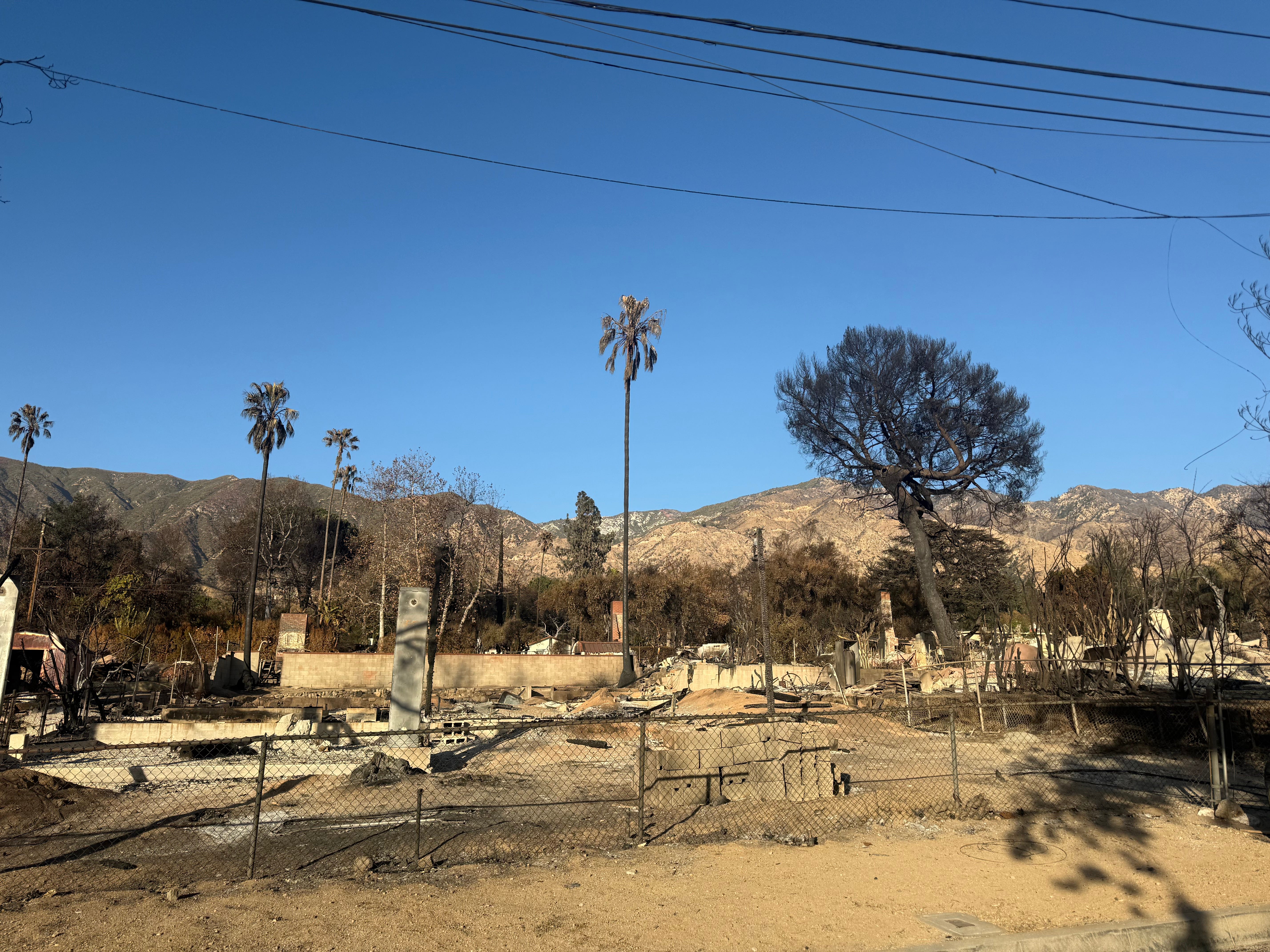
On Las Flores, from Lake Ave. in the east to Olive Ave. in the west, a stretch of just over a mile and seven large blocks, only 12 houses still stand out of approximately 182 homes that were once there. (This also accounts for houses on the corners as well, that may not have officially had a Las Flores address.) Those that do remain often have notable damage, a partially burnt fence or a lost garage – on one of the most destroyed stretches of homes in the Eaton fire footprint, which before the fire was the street I called home.
In publicly available maps of Southern California Wildland Urban Interface areas it shows that the Eaton fire largely stayed within those boundaries, even when being pushed by eighty to one-hundred mile an hour winds on January 7 and 8.
However, part of the theorized reason it only went so far and was largely held within the Wildland Urban Interface area was that the fire department in Pasadena essentially held the line at Woodbury (West Altadena’s southern boundary)), making sure that the fire didn’t cross their jurisdiction even as the winds pushed the embers far beyond Altadena. (This just applies for the west side of the fire and later on January 8, and does not account for the spread following the ignition of the Eaton Fire on the first night into areas of East Pasadena and Sierra Madre.)
While wind driven, the fire was also heavily influenced by terrain, according to Edgar McGregor an Altadena resident and meteorologist who has been credited for saving thousands of lives in Altadena during the Eaton Fire.
In the hours and days before the fire he told followers of his Facebook, Substack and other social media accounts to “leave” Altadena if a fire in the area did erupt, and to have “their cars packed and ready to go” due to the severity of the impending mountain wave wind event.
Following the fire, McGregor posted on Facebook about having drawn a near perfect map of how an Altadena firestorm would play out in April 2024, almost exactly mirroring the events of Jan. 7 and the following days. He told his followers in the Altadena Weather and Climate Group that the “Eaton Fire was so damn predictable.”
“The rotor motion [in Eaton Canyon] suppressed embers from flying over the ridge around where the Midwick gate sits [the Midwick gate is on the west side of Eaton Canyon],” McGregor wrote in the post. “West of Allen, there is no ravine separating the homes from the hills, and so the fire was able to run in freely.”
When asked to provide comment about the missteps by the county in West Altadena, Kathryn Barger, the LA County Supervisor for Altadena and surrounding areas, did not respond to a request for comment.
While the LA County Fire Department did respond to a request for comment, they did not directly answer any of the questions I asked, including those about what residents had said about them standing by and about leaving the park without any notification.
“The County of Los Angeles Fire Department acknowledges the immense loss and challenges faced by our communities during the wildfires and remain deeply committed to supporting those affected,” their Public Information Office wrote in an email. “We continue to participate in the comprehensive third-party evaluation of all response efforts. This review focuses on identifying areas of strength and pinpointing opportunities for improvement. The Fire Department remains committed to prioritizing and fully engaging in this process. Beyond that, we have no further comment at this time.”
California has eliminated some of the permitting required for building including the California Environmental Quality Act and the California Coastal Act in order to streamline the rebuilding process in Altadena and the Palisades, but still necessitates new builds to have indoor sprinklers, avoid the use of gas appliances, and other costly alternatives in high fire risk areas. Requirements some find to be cost prohibitive and something that in most cases insurance or the county has been unwilling to cover, according to various residents that plan to rebuild.
“All these requirements, they were made for a different type of person building homes,” Chambers said. “They’re for rich people that wanted to tear down an old home and build a new one, or had a bunch of money and wanted to build their dream home. But we’re a whole different class of people that need homes. We’re not trying to build our dream homes, we’re trying to stay next to our jobs, our employers, so that we don’t have to commute an hour and a half every day.”
Halsey said that having indoor sprinklers as a future proof solution is “a stupid idea” saying that we should be taking a cue from both the Canadians and the Austrailians and consider both defensible space and rooftop sprinklers instead of indoor ones.
“It [fire] doesn’t happen on the inside,” Halsey said. “It’s coming from the outside now and we can’t get our head around it. So we keep requiring sprinklers inside and the houses keep burning. And so wet homes just won’t burn.”
Chambers said that his aunt’s home in Altadena had burnt even though it had indoor sprinklers, a failed effort to hold the flames that came from outside at bay.
The expansion of the Wildland Urban Interface has triggered a number of changes to state laws, the expansion of the CalFire High Wildfire Risk Maps released in the first three months of 2025 and regulations on the materials used in construction, and the amount of defensible space that is required around structures.
These maps are used to establish and determine the need for home hardening, defensible space requirements, and other considerations for protective measures. This does not determine or govern what will or will not be covered by insurance companies, according to CalFire. Insurance agencies have their own internal models and risk assessment determinations. As a part of these internal models, many homeowners across the state in these high fire risk areas have been dropped and are on the bare minimum plan provided by the state.
The California Fair Plan is for all Californian’s and meant to only be a “temporary safety net,” however many have become reliant on their services on a more permanent basis in high risk areas.
Another challenge that both policymakers and fire departments face when trying to get prescribed fires onto the landscape cause a lot of reasons for delays, and red tape.
Southern California has become famous for its dangerous wind whipped and dry brush fueled fires over the last several years, but its flora and fauna can be overrun by too much fire as the typical natural cycle is every 30 to 150 years or more, according to multiple studies on fire ecology in the region.
But for prescribed fire to be effective and make an impact – even if its a negative one is every five years or less. And fires that occur frequently in an environment like the chaparral dominated South and Central California can have long lasting consequences, like the complete erasure of the chaparral environment and being replaced with highly flammable and invasive grasses. This was intentionally done by the Chumas and Tonva to clear space for hunting and other, but weren't set as a means to control future fires. And fires that did start were allowed to run their course, with no intention of suppression.
There can be additional impacts beyond the shrinking native habitats when these areas are burnt, including the timing of these burn practices in the late winter and spring can interrupt and disturb breeding grounds and habitats for animals, reptiles and birds, some of whom nest on the ground, according to research done by Los Padres Forest Watch.
“They’ll do it in the spring right when everyone is nesting, right when the animals are coming out of the ground, and the soil is still moist,” Halsey said. “So what that does, not only takes out the animals, but turns the water into steam, so we think what happens is it boils or steam fries the seeds and the organisms in the soil. So you can cause instant type conversion of shrublands to grasslands in that situation.”
In a near complete reversal of what is needed in Southern California, the landscapes of Northern California’s wildlands are dominated by tall stands of trees and rely on fire for the survival of the ecosystems and a much lower natural rate of return.
But, climate change and the extreme fire suppression strategy has caused many of the fires that burn in these areas to burn so hot that it destroys everything in its path, including the trees. In what is widely known as ‘crown fire’ churning through forested environments and forever altering them into stands of blackened trees and grasslands.
Many of the fires that burnt large swathes of forested land came in an era before heavy fire suppression and the “out by 10” rule – which required a fire to be fully suppressed before 10 a.m., the morning after it started. This policy was implemented in 1935 by The Forest Service after several large fires charred millions of acres of timberlands in the preceding three decades, according to the Forest History Society. This policy was later disbanded in the 1970’s when scientists started to conclude the positive role fire played in the ecologies of the forest.
Organizations like California Chaparral is in the process of suing CalFire to prevent them from implementing their wildfire prevention plan which includes targeted logging, use of pesticides, prescribed fire, and thinning, methods the organization calls damaging to the ecosystem and instead asks CalFire to reconsider its plans and find more eco friendly ways to move forward.
“The lawsuit alleges the Program is misguided in utilizing the same techniques that have not worked in the past,” California Chaparral said in a statement when they filed their lawsuit in early 2020. “And that in fact create[s] conditions that increase the rate of fire movement, facilitate the spread of embers, and allow for increased wind speeds, all of which endanger homes and communities.”
Despite the ongoing lawsuit by California Chaparral, which is set to be heard in court again on May 12, CalFire continues to employ the methods outlined in their mitigation plan, according to public datasets on fuel treatments across the state.
But as a shift back towards prescribed fire and an acceptance of its need in this changing climate, California passed a law that allows federally recognized tribes in the state to conduct cultural burns without their permission. The Karuk in far Northern California along the Klamath River became the first tribe to return fire to land under the new law earlier this year, a return to tradition for the tribe who had been outlawed from doing such practices since the early 20th century.
However in Southern California in the Chaparral dense mountains, fire suppression policies were implemented in 1919 after several devastating wildfires. This history of suppression has created fuel loading so high that when it burns it can change the chemical and structural composition of the soil which could lead to landslides and erosion, according to Mike Davis’ 1998 “The Case for Letting Malibu Burn.”
But Halsey debates that claim, saying that any claims that the soil changes its composition following a fire is just wrong and an excuse to cut, burn and lace the chaparral with chemicals. And in most cases landslides which happen after this change in soil makeup, is really about whether or a shrub's roots are there to hold the land in place, and not about any hydrophobic nature of the soil in a post fire landscape.
“Oh my god the chaparral burns so hot, the waxes, the material get into the soil, they create a hydrophobic layer,” Halsey said. “It once again it feeds into this thing, get rid of the chaparral, right?”
Despite the ending of that strict suppression policy, much of that same ideology remains today and fires are often suppressed as quickly as possible. That policy of suppression is important in the chaparral environment, according to Halsey. Otherwise there is a risk to both the ecology and already struggling habitats when these environments in Southern California burn on a more frequent basis.
“So in Chaparral we've got to reduce the number of fires in those systems right now because fire suppression has actually protected shrubland ecosystem from disappearance,” Halsey said. “Because they can't handle frequent fire any more than that once every 30 years. And you have people running around saying we should burn it every five to 10 because the Native Americans supposedly did. Well, if they did, it wouldn't be here anymore.”
Across the state utility companies have been responsible for hundreds of wildfires, big and small, typically when power lines have sparked and ignited dry vegetation, sometimes in high wind events. Other utility induced causes include not enough space in between trees and wires clearance from wires, a lack of maintenance on aging equipment and often non-existent firebreaks which are required under state law.
Some of the most notable fires in the last several years caused by utilities across the state include the Camp Fire in 2018 that wiped out the town of Paradise, and the Thomas Fire which tore through Malibu in 2017, and many more of California’s most destructive and largest wildfires in the last several years, according to findings by CalFire.
And now in 2025 preliminary findings by fire investigators, claims by lawyers and views held by the Altadena community are citing alleged evidence that the Eaton fire was started by a SoCal Edison owned high voltage line arcing in high winds on the evening of January 7. But, now in a widely reported April earnings call, the President and Chief Executive Officer of Edison International Pedro Pizarro said that Edison may very well be the ignition source of the Eaton fire.
“While SCE has not conclusively determined that its equipment was associated with the ignition of the Eaton Fire, it is also not aware of evidence conclusively pointing to another source of ignition,” Pizarro said, in the call.
Whatever happened, one thing many know is that the climate is changing, and that people were left to die, and that the Eaton fire was a catastrophic failure on all levels, from every authoritative department.
Like many said at the listening session I attended, West Altadena and its community “was left to die,” and when something like this happens again, and I hope it doesn't, we residents should know “that we are on our own” and government won’t be there to help us.
I’ll continue to cover the Altadena recovery process over the next few years.